Preparation of Spatial database for proposed Night Safari at Bannerghatta, Karnataka using DGPS, Total Stations, Satellite Images and carryout Hydrological and Geotechnical investigations.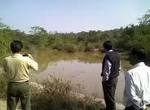 The project involved large scale mapping of the project area using DGPS, Total Stations and High Resolution Satellite images. The final data was used to prepare a Master plan for the Night Safari Read More . The project involved large scale mapping of the project area using DGPS, Total Stations and High Resolution Satellite images. The final data was used to prepare a Master plan for the Night Safari Read More . |
Preparation of GIS database using GPS, High Resolution satellite images and carryout spatial analysis in choosing suitable sites for setting up new facility for NetApp .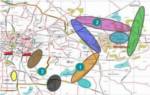 The project involved creation of GIS database using GPS survey and high resolution satellite images. Details on local hydrology Read More . . The project involved creation of GIS database using GPS survey and high resolution satellite images. Details on local hydrology Read More . . |
Mapping of Lion Safari Area at Thyavarekoppa in Shimoga, Karnataka using GPS and Satellite Images.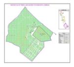 The Objective of the project was to prepare a GIS database for the Lion Safari Area using GPS survey and Satellite images .. The Objective of the project was to prepare a GIS database for the Lion Safari Area using GPS survey and Satellite images ..Read More . . |
Biomass Energy for Rural India-Topographic survey and creation of GIS database for 25 villages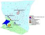 This project is being carried out for BERI (Biomass energy for Rural India) a UNDP and GOI funded project. The scope of work involves topographic survey of settlements in 25 selected villages in Tumkur districtRead More . . This project is being carried out for BERI (Biomass energy for Rural India) a UNDP and GOI funded project. The scope of work involves topographic survey of settlements in 25 selected villages in Tumkur districtRead More . . |
Delineation of prospective zones for Gold mining In Gadag Schist Belt using Remote Sensing, Geophysical Data and Data collected from field.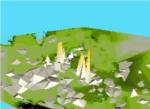 The purpose of the project was to delineate prospective zones for gold mining in selected blocks of the Gadag schist belt. The scope of the work included preparation of GIS database Read More . . The purpose of the project was to delineate prospective zones for gold mining in selected blocks of the Gadag schist belt. The scope of the work included preparation of GIS database Read More . . |
DGPS Survey for GCP establishment and high resolution image rectification for Hydro Power Potential Estimation in Uttaranchal.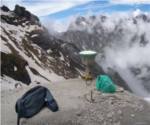 This project was carried out for the IL&FS and Uttaranchal State Govt. Joint Venture for Hydropower development. The project involved establishment of ground control points (GCPs) Read More . . This project was carried out for the IL&FS and Uttaranchal State Govt. Joint Venture for Hydropower development. The project involved establishment of ground control points (GCPs) Read More . . |