Ward Vision – Building level landuse and Infrastructure mapping
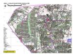 This project has been carried out for Bangalore Development Authority and Janaagraha. The source data that was used was data captured from aerial photography Read More . . This project has been carried out for Bangalore Development Authority and Janaagraha. The source data that was used was data captured from aerial photography Read More . . |
DGPS Control Station Establishment for Topographical Survey of Proposed Expressway from Outer Ring Road to Bangalore International Airport For RITES
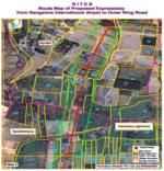 The Project was executed using two Sokkia DGPS Dual Frequency Receivers. Six pair points were established at regular intervals along the corridor Read More . . The Project was executed using two Sokkia DGPS Dual Frequency Receivers. Six pair points were established at regular intervals along the corridor Read More . . |
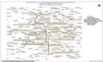 This project involved the transfer of surveyed alignment of the proposed metro rail onto a georeferenced base map by making use of a High resolution satellite image,Read More . .
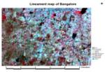 This project involved the interpretation of satellite imagery for delineation of lineaments for Bangalore district. Read More . .